
This notebook shows how to access the ERAD 2026 Serbian radar dataset hosted on the NSF Open Storage Network (OSN), part of the radar-datatree initiative by Atmoscale. Two access patterns are demonstrated:
| Access pattern | What you get | When to use |
|---|---|---|
Raw .vol files | Per-moment Rainbow binary files | Original vendor format (QC, re-processing) |
| ARCO Zarr stores | Analysis-Ready Cloud-Optimized xarray DataTrees | Instant slicing by time, elevation, or variable |
Two sites, three dates each (2014, 2017, 2026):
| Site | Radar | Type | Task | Moments |
|---|---|---|---|---|
| Fruska Gora (FGora) | Selex/Leonardo | Single-pol | DEJSTVO | DBZH, DBTH, VRADH, WRADH |
| Jastrebac | Selex/Leonardo | Dual-pol | JSTB_250_Dp_leto | + ZDR, KDP, PHIDP, RHOHV, uPhiDP |
Setup
import cmweather  # noqa: F401 -- registers the HomeyerRainbow colormap
import fsspec
import icechunk
import rioxarray  # noqa: F401 -- registers the .rio accessor used for the composite CRS
import xarray as xr
import xradar

OSN_ENDPOINT = "https://umn1.osn.mghpcc.org"
BUCKET = "nexrad-arco"
Part 1: Raw .vol file access
Rainbow .vol files are stored per-moment: each file holds one radar variable (e.g., reflectivity dBZ, velocity V) across all 12 elevation sweeps for one timestamp. A complete volume is reconstructed from the 4 (single-pol) or 9 (dual-pol) per-moment files sharing the same YYYYMMDDHHMMSSss filename prefix.
Browse available files
fs = fsspec.filesystem(
    "s3", anon=True, client_kwargs={"endpoint_url": OSN_ENDPOINT},
)

for site, prefix in [("FGora", "fgora_vol"), ("Jastrebac", "jastrebac_vol")]:
    files = sorted(fs.glob(f"{BUCKET}/{prefix}/**/*.vol"))
    print(f"{site} raw files: {len(files)}")
    for f in files[:4]:
        print(f"  {f.split('/')[-1]}")
    print()
FGora raw files: 324
2014051500012000V.vol
2014051500012000W.vol
2014051500012000dBZ.vol
2014051500012000dBuZ.vol
Jastrebac raw files: 864
2014051500010400KDP.vol
2014051500010400PhiDP.vol
2014051500010400RhoHV.vol
2014051500010400V.vol
Open a single .vol file
xradar’s Rainbow reader uses memory-mapped I/O, so it needs a local path. fsspec.open_local with simplecache downloads on first access and caches locally.
fgora_raw = sorted(fs.glob(f"{BUCKET}/fgora_vol/**/*.vol"))
sample_file = fgora_raw[2]  # a dBZ file
print(f"File: {sample_file.split('/')[-1]}")

local_path = fsspec.open_local(
    f"simplecache::s3://{sample_file}",
    s3={"anon": True, "client_kwargs": {"endpoint_url": OSN_ENDPOINT}},
)
dtree_raw = xradar.io.open_rainbow_datatree(local_path)
dtree_raw
File: 2014051500012000dBZ.vol
sweep0_raw = dtree_raw["/sweep_0"].to_dataset(inherit="all_coords")Download files locally (optional)
If you prefer working with local files, you can download a single timestamp’s worth of per-moment files:
from pathlib import Path

download_dir = Path("data/fgora_sample")
download_dir.mkdir(parents=True, exist_ok=True)

sample_ts = "2014051500012000"
for remote in [f for f in fgora_raw if sample_ts in f]:
    local = download_dir / Path(remote).name
    if not local.exists():
        fs.get(remote, str(local))
    print(f"  {local.name}")
2014051500012000V.vol
2014051500012000W.vol
2014051500012000dBZ.vol
2014051500012000dBuZ.vol
Part 2: ARCO Zarr access
The same data as Analysis-Ready Cloud-Optimized (ARCO) Zarr stores — pre-merged, pre-aligned, and indexed along a vcp_time dimension. Each store is an icechunk-versioned Zarr v3 archive following the radar-datatree data model by Atmoscale. The top-level group is the task name, with 12 sweep children containing CF-compliant moment arrays indexed by (vcp_time, azimuth, range).
Three stores are published to keep range axes physically consistent — Jastrebac splits across two stores because the 2014 dataset uses 250 m bins (1000 bins → 250 km range) while the 2017 and 2026 datasets use 500 m bins (~500 bins → 250 km range). Merging them into a single range axis would mis-label the 500 m data in physical space.
| Store prefix | Coverage | Bin width × count |
|---|---|---|
Fgora/ | FGora, 2014 + 2017 + 2026 | 1000 m × 250 |
jastrebac_250m/ | Jastrebac, 2014 | 250 m × 1000 |
jastrebac_500m/ | Jastrebac, 2017 + 2026 | 500 m × 500 |
Open one store
Below opens FGora (single-pol, spans all three dates). To open one of the Jastrebac stores instead, swap the commented-out prefix= line in.
prefix = "Fgora"  # single-pol, 12 sweeps × 360 az × 250 range, 2014 + 2017 + 2026
# prefix = "jastrebac_250m"  # dual-pol, 12 × 360 × 1000, 2014 only
# prefix = "jastrebac_500m"  # dual-pol, 12 × 360 × 500,  2017 + 2026

storage = icechunk.s3_storage(
    bucket=BUCKET,
    prefix=prefix,
    endpoint_url=OSN_ENDPOINT,
    region="us-east-1",
    anonymous=True,
    force_path_style=True,
)
repo = icechunk.Repository.open(storage)
dt = xr.open_datatree(
    repo.readonly_session("main").store,
    engine="zarr",
    consolidated=False,
    chunks={},
)
dtInspect dimensions, range axis, and moments
task = next(iter(dt.children))  # "DEJSTVO" or "JSTB_250_Dp_leto"
ds = dt[f"/{task}/sweep_0"].to_dataset(inherit="all_coords")
rng = ds["range"]
moms = sorted(
    v for v in ds.data_vars
    if v not in {"sweep_fixed_angle", "ray_elevation_angle", "sweep_number"}
)
print(f"Task    : /{task}")
print(f"Dims    : {dict(ds.sizes)}")
print(
    f"Range   : {int(rng.size)} bins @ {float(rng[1] - rng[0]):.0f} m"
    f"  (first gate {float(rng[0]):.0f} m, last {float(rng[-1]):.0f} m)"
)
print(f"Moments : {moms}")
Task : /DEJSTVO
Dims : {'vcp_time': 100, 'azimuth': 360, 'range': 250}
Range : 250 bins @ 1000 m (first gate 500 m, last 249500 m)
Moments : ['DBTH', 'DBZH', 'VRADH', 'WRADH']
Part 3: Gridded QPE composite
The two stores above are polar data, one radar each. The course workflow turns them into a single Cartesian composite — quality-controlled, attenuation-corrected, converted to rain rate and merged across both radars onto a 1 km grid. See Composite To Grid — with QC for how it is produced.
Unlike the ARCO stores, this product is a plain Zarr v3 store, so no icechunk session is
needed — xr.open_zarr opens it directly.
composite_url = f"s3://{BUCKET}/composite.zarr"comp = xr.open_zarr(
composite_url,
storage_options={"anon": True, "client_kwargs": {"endpoint_url": OSN_ENDPOINT}},
consolidated=False,
decode_coords="all",
)
compThe store is self-describing — CF standard names, units and the projection travel with it:
print(f"Conventions : {comp.attrs['Conventions']}")
print(f"CRS         : {comp.rio.crs.to_string() if comp.rio.crs else 'not decoded'}")
print(f"Grid        : {comp.sizes['y']} × {comp.sizes['x']} @ 1 km")
print(f"Times       : {comp.sizes['vcp_time']} steps, "
      f"{str(comp.vcp_time.values[0])[:16]} → {str(comp.vcp_time.values[-1])[:16]}")
for v in comp.data_vars:
    a = comp[v].attrs
    print(f"  {v:10} [{a.get('units', '-'):7}] {a.get('long_name', '')}")
Conventions : CF-1.10
CRS : PROJCS["unknown",GEOGCS["unknown",DATUM["Unknown based on GRS 1980 ellipsoid",SPHEROID["GRS 1980",6378137,298.257222101199]],PRIMEM["Greenwich",0,AUTHORITY["EPSG","8901"]],UNIT["degree",0.0174532925199433]],PROJECTION["Lambert_Azimuthal_Equal_Area"],PARAMETER["latitude_of_center",52],PARAMETER["longitude_of_center",10],PARAMETER["false_easting",3760756.24647297],PARAMETER["false_northing",-2656141.30068788],UNIT["metre",1,AUTHORITY["EPSG","9001"]],AXIS["Easting",EAST],AXIS["Northing",NORTH]]
Grid : 675 × 654 @ 1 km
Times : 38 steps, 2017-08-12T15:00 → 2017-08-12T18:05
DBZH [dBZ ] Attenuation-corrected horizontal reflectivity composite
n_radars [1 ] Number of radars contributing to each cell
rain_rate [mm h-1 ] Rain rate composite from Marshall-Palmer Z-R
| Variable | Units | Meaning |
|---|---|---|
DBZH | dBZ | Attenuation-corrected reflectivity composite |
rain_rate | mm h⁻¹ | Rain rate from Marshall-Palmer Z-R |
n_radars | 1 | How many radars saw each cell (0, 1 or 2) |
rr = comp.rain_rate.isel(vcp_time=comp.sizes["vcp_time"] // 2)
rr.where(rr > 0.1).plot(cmap="HomeyerRainbow", vmin=0, vmax=30, figsize=(8, 7),
                        cbar_kwargs=dict(label="rain rate (mm h$^{-1}$)"))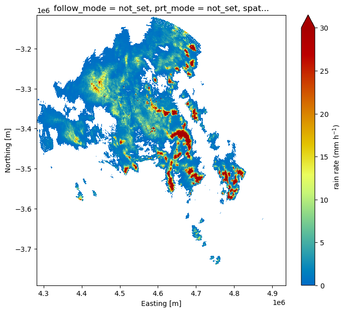
Summary
Raw .vol files | ARCO Zarr (icechunk) | QPE composite (Zarr) | |
|---|---|---|---|
| Location | s3://nexrad-arco/{site}_vol/{date}/*.vol | s3://nexrad-arco/{Fgora, jastrebac_250m, jastrebac_500m}/ | s3://nexrad-arco/composite.zarr |
| Format | Rainbow binary (one moment per file) | Zarr v3, chunked, CF-compliant | Zarr v3, CF-1.10, self-describing |
| Geometry | Polar, per radar | Polar, per radar | Cartesian 1 km LAEA, both radars merged |
| Access | fsspec.open_local + xradar | icechunk + xr.open_datatree | xr.open_zarr(..., decode_coords="all") |
| Time indexing | Manual (parse filenames) | Built-in vcp_time dimension | Regular 5-minute vcp_time |
| Best for | Re-processing, format-specific QC | Analysis, visualization, ML | Nowcasting, hydrology, verification |
| Coverage | 3 dates × 2 sites (1188 files) | FGora 3 dates + Jastrebac 2014 (250 m grid) + Jastrebac 2017/2026 (500 m grid) — 3 stores, 196 volumes total | Lowest sweep (0.5°), one case per store |
References
radar-datatree — hierarchical data model for ARCO radar archives
Atmoscale — cloud-native weather radar infrastructure
icechunk — version-controlled Zarr storage
xradar — xarray-based radar I/O library